Watershed Monitoring
Near-real-time monitoring to detect any effects of irrigation withdrawal on surface and groundwater in accordance with an Environmental Act proposal. The project involves measuring and reporting creek inflow, outflow, well levels, and volume of water extracted using flow meters. Full LoRaWAN setup using a wide range of devices and sensors.


Measuring Weather Conditions for Orchard Management
New all-in-one weather stations have been installed in tree fruit production areas to provide information for pest management. The stations monitor 12 parameters and communicate using LoRaWAN.

Vineyard Temperature Monitoring
A local vineyard is looking to expand production but needs to know whether the microclimate of the new area will provide the appropriate conditions for growth. So we’ve set up a local LoRaWAN network and wireless temperature sensors across the area to be able to monitor and analyze the temperature differences.

Salinity Monitoring Along the Fraser River
Working with a group of local farmers to capture and display sensor data that can be used to monitor irrigation water quality along the Fraser River in Delta, British Columbia. The project consists of retrieving salinity, depth, temperature, tide, flow, and weather information from various sources and making it readily available to stakeholders. Additional sensors and functionality are being added.


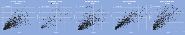
Evaluation of Reanalysis Datasets
Accurate and granular weather data is key to providing effective parametric insurance coverage that minimizes basis risk. A large client contracted Peak HydroMet to evaluate several reanalysis models to identify the most appropriate for agricultural index insurance in Canada. Model results were compared with high-quality station observations to determine the strength and weaknesses of each model. The best options were identified.
Wireless Sensors
Recognizing the need for easy-to-setup sensors and an easy-to-use weather platform, we’re working on building out some dashboards that are based on affordable wireless sensors.
The example below is from a cranberry farm that has a main station monitoring temperature and rainfall and another in-field sensor that measures temperature.

These two sensors are only about 200m apart but show significant differences. During the daytime, the infield temperature is 1 to 2°C warmer. During the night, infield temperature is 1 to 2°C colder. This is important for frost protection or any other in-field management that relies on temperature.


The inset map shows the locations of the sensors. “RG” (Rain Gauge) is where out-of-field temperature and rain is monitored. “Temp Sensor” is the in-field temperature (shown in picture). The red marker is the location of the LoRaWAN gateway.

Until now, this operation has been using wired temperature probes (pictured below) to detect in-field temperatures for frost mitigation. Sensors get installed near the middle of each field using hundreds of metres of expensive wire – wire that gets caught in machinery, chewed by rodents, and is subject to signal loss. Wireless sensors are so much easier, more versatile, and economical.
Agricultural Weather Monitoring Network in British Columbia
Over the past few years, we’ve had the pleasure of working with BC Climate & Agriculture Initiative, BC Agricultural Climate Adaptation Research Network, and several industry groups to develop strategies to improve agricultural weather monitoring in BC. We are in the process of executing these strategies that will improve weather monitoring and offer new tools for producers.

Farmers Edge Field-Centric Weather


For the past five years, I’ve been working closely with Farmers Edge Inc. to deploy the largest private agricultural monitoring network in the world. With over 6500 in-field weather stations located throughout Canada, the United States, Brazil, Australia, Ukraine, and Russia, these stations provide real-time insight for crop management. We’ve also installed nearly 700 soil moisture probes to monitor soil soil conditions for irrigation and yield forecasting.
Parametric Insurance

Presented on the topic of Parametric Insurance at the 2021 Manitoba Agronomists’ Conference. Follow-up article published in the Western Producer.
FCC AgOutlook 2016 – Weather Outlook for 2016

Crop Residue Burning Decision Support Tool for the Province of Manitoba
Using a numerical weather prediction (NWP) model (North American Mesoscale Model – NAM) to provide insight into surface winds, transport winds, mixing layer height, and ventilation.

Agricultural Weather Monitoring and Decision Support Tools for the BC Peace Region
The project goal was to increase the availability of weather information and decision support tools for agricultural producers in the BC Peace region. So far, an additional 20 weather stations have been installed. Weather information and tools can be accessed at the Peace Region Agri Weather Network Website
